HISTORICAL MINIATURES JOURNAL ISSUE NUMBER 5
PUBLISHED
BY GEORGE GRASSE
PHOTO TOUR
OF THE FIRST BATTLE OF BULL RUN 1861 (PART 1)
By George Grasse
 |
| OVERVIEW
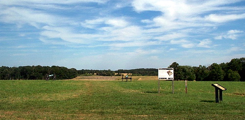
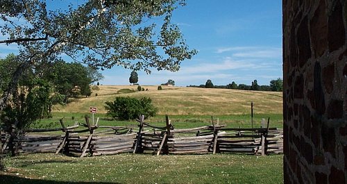
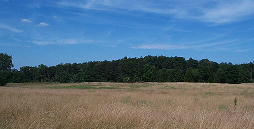
FROM MATHEWS HILL. This is the view that the first Union
troops had of what was to be the battlefield of the First Battle of
Bull Run, 21 July 1861. It is taken from the broad crest
of Matthews Hill. At the far edge of the crest at the line of
artillery pieces is a large swale and across from it is Buck Hill where a
large part of Evans' Confederate Brigade attempted
a delaying action after discovering the Union flank march along the Sudley Springs Road off camera to the right.
The Confederate brigades of Bee and Bartow came up to support Evans
and between them they made several attempts to disrupt the
deployment of Hunter's Union division. However, the Union
brigades of Burnside and Porter were able to repel the Confederates
and, with more troops arriving from Heintzelman's Union division,
the Confederate line collapsed around noon. From Buck Hill,
Evans, Bee, and Bartow retreated in some disorder across the
Centreville Road (now US 29) and up the slopes of Henry House Hill
which can be seen in the
far distance marked by a small field just above the barrel of the
gun in the center of this photo. The
main battle would be fought there.1 |
 |
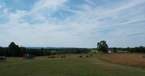
| MATHEWS HILL
AND HENRY HILL. Union troops crested the hill and could
see Evans' Brigade fading away in the distance. The M.
Matthews house was in this immediate area. Also seen from
this view is the Henry House and probably the Confederate brigades
of Bee and Bonham forming up just behind the house off to the right
and near the skyline. Other
Unions brigades in column continued down the Sudley Springs Road
toward Henry House Hill will the immediate infantry on Matthews Hill
started forward to keep pressure on Evans. |
 |
|
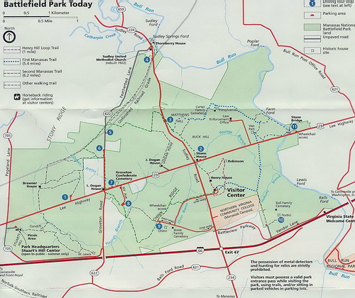
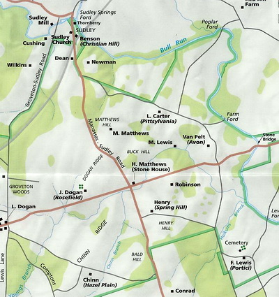
MANASSAS NATIONAL BATTLEFIELD MAP: Matthews Hill
is number 3 (blue circle) on the map. Union troops were arriving from
Sudley Springs which is number 4 on the map. Evans' Confederate Brigade
was on Bull Run at the Stone Bridge, number 11. General Evans recognized
the flanking movement, left the smaller portion of his brigade to cover the
bridge and marched with the larger portion to contend the Union column from
Sudley Springs. The first clash occurred on Matthews Hill. As
several Union brigades came on line against Evans, the Confederate line was
threatened and Evans fell back over Buck Hill, past the Stone House, across the
Centreville Road, and up the slope of the Henry House Hill towards the Robinson
House. By this time, the Confederate brigades of Bee and Bonham had
arrived and were deploying into line on Henry House Hill in the general vicinity
of the Park's Visitor Center. (This map courtesy of the National Service) |
 |
 |
|
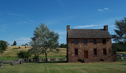
THE STONE HOUSE: The left photo shows the back of the Stone House standing at
the crossroads of the Centreville and Sudley Springs roads. The Henry
House is visible at the top of the hill across the road. The right photo
is within fifty feet of the Centreville Road looking up the slope of the Henry
House Hill. The house is visible at the crest with a large tree standing
behind it. At this level of ground, the Confederate brigades of Bee and
Bartow could not be seen but their skirmishers were deployed just below the
crest and reported the progress of the Union advance most of which would
concentrate to the right of these photos using the axis of the Sudley
Springs/Manassas Road as a guide. This road is just visible in the left
photo near the bottom right corner where cars are lined up at the traffic light.
|
 |
|
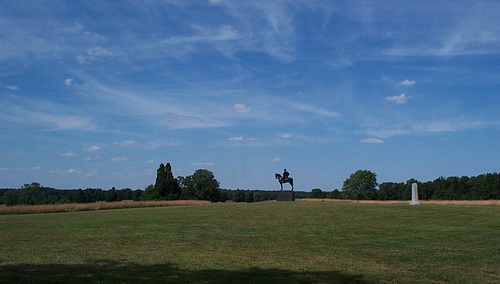
HENRY HOUSE HILL - UNION POSITION: This photo was taken from the large
"plateau" area of Henry House Hill looking towards the vicinity of Matthews Hill
which is the small patch of open field just to the left of the large tree that
stands next to the Henry House on the right. Union troops came up the
reverse slope on a broad front and immediately took fire from the three battered
Confederate brigades of Evans, Bee, and Bartow. Jackson's fresh Virginia
brigade was on its way. Their line runs from a point
behind the camera off to the right. The fire fight lasted some time with
the Confederates getting the worst of it. The gun line represents the
approximate position of Griffin's and Rickett's exposed batteries with the
supporting infantry line behind them slightly down slope. 2 |
 |
| MAP
SHOWING PLACE NAMES AS THEY APPEARED IN 1861: This map
shows the relative location of the famous place names of the First
Battle of Bull Run. (This map
courtesy of the National Park Service) |
 |
| HENRY
HOUSE HILL - CONFEDERATE POSITION: This
photo was taken near the spot where the Union position photo was
taken and the view is to the northeast. Jackson's Confederate
brigade arrived on line relieving the battered brigades of Evans,
Bee, and Bartow and was well supported with artillery. In the
high grass field on the right and in front of the woods is the
location where Jackson's brigade formed up and then advanced to
engage the Union brigades of Sherman, Porter, Franklin, and Willcox.3 |
 |
| THE FIELD
BEHIND THE CONFEDERATE LINE: Of significance is the
placement of artillery pieces near the edge of the wood from which
they could support Jackson and cover Evans, Bee, and Bartow. |
 |
|
JACKSON'S RIGHT: This photo was
taken slightly down slope from Jackson's line. This was
General Bee's old position and roughly where he was killed.
Off camera to the left is where Confederate General Hampton's Legion
came up to support Jackson. Eventually, the brigades of Cocke
and Bonham would arrive. In a future issue, part 2 will cover
the reverse of fortunes and the Confederate flank attack at the
Chinn House. |
 |
|
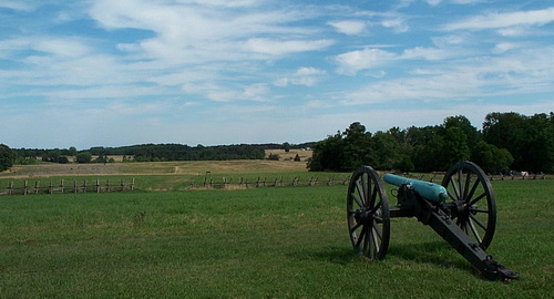
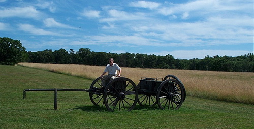
CAISSON: This combination of
wheeled vehicles is the caisson, one per gun. It is a standard
gun limber pulling a caisson unit which has two ammunition chests
and spare wheel. That's the author in the rider's seat.
Taken on Henry House Hill. |
I TOOK THESE PHOTOS IN
JULY 2009
---------------------------------------------------------------------------------------------------------------------------------
END NOTES AND BIBLIOGRAPHY
1 National Park Service, Manassas National Battlefield Park
brochure, Manassas, Virginia. All photos were taken from
National Park Service property
2
Hill, John. The First Battle of Bull Run, American Civil War
Notebook Series, Geoffrey Wheeler, editor. CartoGraphics, Inc., Fairfax,
VA, 1991
3 Hankinson, Alan. First Bull Run 1861,
Osprey Campaign Series. London: Osprey Publications, 1991
GO TO?
© Copyright by George Grasse